Ready for a new challenge Jo Bennie traces a detailed path from Aviemore to Braemar, Scotland — a challenging route coming to life in the summer warmth
Avibra one goes by the high mountain pass of the Lairig Ghru; to create an alternative lower level route (Avibra two) I traced the old drover’s route which followed the River Spey out of Aviemore to the River Feshie. From there I traced up the Feshie, over the watershed to the Geldie Burn and down the Geldie to the River Dee and Braemar.
From Aviemore, Avibra two turns away from the Spey onto the B970 to Loch Morlich. At Inverdruie it moves onto paths through the woods past Loch an Eilein, linking back up with the drover’s route at Feshiebridge.
It bears the marks of the glaciers that scoured the Caringorms during the last ice age
It’s a longer route than Avibra one but it runs lower and gentler. Glen Feshie is reputed to be one of the most beautiful in Scotland, and I think I agree. It is also geologically fascinating. It bears the marks of the glaciers that scoured the Caringorms during the last ice age, tearing Lairig Ghru pass out of the Cairngorm granite massif.
Aviemore has excellent public transport links, both train and coach, and plenty of places to stay for all budgets. Braemar is connected to the city of Aberdeen by a 2 hour bus journey.
Starting off
I took a taxi from Aviemore to Feshiebridge to shorten my walk — I plan to walk the link later. Joint pain due to menopause tricks my brain into thinking I’m more tired than I am. It turned out to be a good call as a previous ankle sprain injury to the ankle also flared (now in proper rehab).
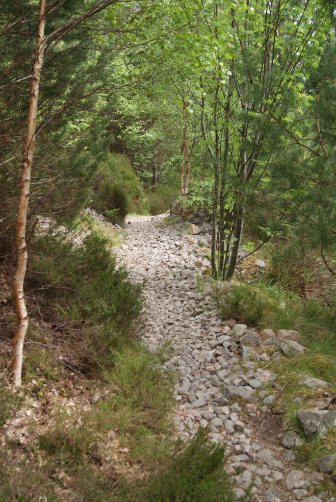
Just after the bridge at Feshiebridge there’s a clear signpost to the footpath at a line of houses. The path winds through woods then out into the open on the banks of the Feshie. The river twinkled prettily out of a vast field of boulders, so small, tinted green, but the calmness is a deception. The Feshie is the most dynamic gravel bed river in Scotland. After storm or snowmelt the river swells fast, torrents scour out new courses, rip chunks out of the banks, tear down great trees and bear boulders downstream.
It’s been so miserable for so long, and now the hawthorn and the rowan were blooming frothily
However, on this gentle sunny day the path wound comfortably and clear along the banks coming out onto a paved road which continued on for a while through Scots pines, letting me ease into carrying my heavy pack. There were birds everywhere making the most of our sudden summer. It’s been so miserable for so long, and now the hawthorn and the rowan were blooming frothily, the sun was finally out and the wind a gentle breeze, perfect for walking.
Beside the road to the left a sign indicates the path which drops down to a sturdy footbridge. The sign says that the path ahead has been destroyed and walkers have to cross the Feshie three times but you don’t, there are good paths all the way down the eastern side. I sat and ate my lunch under the footbridge where the Feshie rocketed through a small gorge of vertical shattered rocks.
From here onwards there are various forks in the path that meet up again further on. Take the path furthest away from the river. In several places where the Feshie has moved, huge chunks are gouged out the riverside paths, as I found out facing several precipitous climbs.
‘Your granny could do it’
Coming up out of the Scots pine plantations to the Ruigh Aiteachain bothy I stopped and stared at the old growth Scots pine forest. These enormous beautiful creatures spread wide like a horse chestnut or an oak; it’s the first time I have been privileged to see their natural form rather than the straight pillars of plantations. Wide lawns stretched beneath, I was so tempted to camp here (the two bothies Ruigh Aiteachan and Red House also break up the route nicely, see the Mountain Bothies Association website The Mountain Bothies Association) but I’d only walked 8 miles in and wanted to cover at least a third of my total distance.
Walking in Scotland is ever about how you cope with your careful plans being scuppered by reality
I met a nice man strimming the grass who assured me that there was a path all the way along the river, and if I doubled back there was an alternative along a stalker’s path above us. Not wanting to double back and not wanting to climb I decided to take the lower path. It was passable but not, as the man said, ‘your granny could do it’ walkable. There is a bit where you have to clamber across a vertical rock face but nothing too bad with a bit of care. My granny would have needed a hip replacement.
I meant to camp about 2 miles on from there but walking in Scotland is ever about how you cope with your careful plans being scuppered by reality. The path climbed gently up winding through scrub under crags then emerging out into a barer landscape of heather and bilberry. A 4×4 track was easy walking but little flat land anywhere, and that dotted by the bog cotton flagging soggy peat.
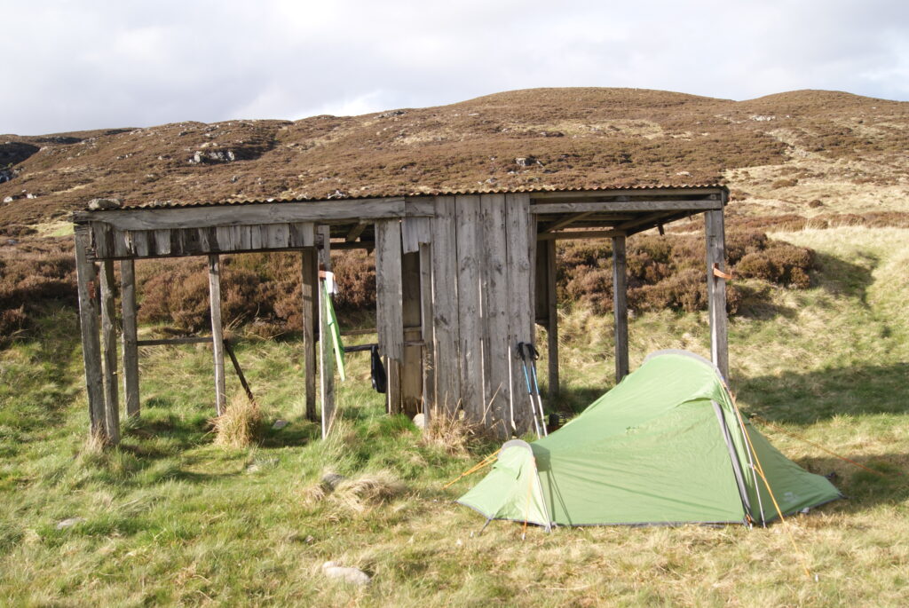
I pushed on through the tiredness towards a little square on the map that I hoped was man-made and would be flatter ground. Coming the other way I met a lovely guy from South Carolina who was heading for the Ruigh Aiteachane bothy. He was walking the Scottish National Trail which is a 537 mile diagonal route from Kirk Yetholm in the Borders to Cape Wrath.
The little square turned out to be a broken down wooden shelter tucked in the lee of a bank constructed from silver bleached wood and a mostly intact corrugated iron roof. It was set back from the deep roar of the Feshie; behind me the Allt Eindart falls were a more lightly toned white static noise.
I got the tent up and boiled water for my little hot water bottle putting it in my sleeping bag before cooking up a gluten free meatloaf mix, which passed. Then to sleep, through the half dark of Scottish nights that is the norm this close to the summer solstice.
A new day
The next day I jinked left on the path to a good footbridge crossing the River Eidiart where it plunges down to join the Feshie. A massive cataract with a huge tempting plunge pool, but I was moving on.
It occurs to me that hiking is a perfect example of being able to hold two contradictory ways of thinking in your head at the same time
My planned destination for this next day was a little set of squares (possibly sheds) on the map under Carn Mor with a stream flowing alongside, giving me a short walk into Braemar the next day. My contingencies were backtracking to camp by the Chest of Dee or camping at the Red House bothy.
It occurs to me that hiking is a perfect example of being able to hold two contradictory ways of thinking in your head at the same time. On the one hand you are immersed in a transcendental world of water and trees, violets and ravens, sunlight moving across a hill, water flowing and pooling and muddying. Forests giving way to scrub and then heather moor on the flanks of the mightiest of Scottish mountains – only Ben Nevis is higher than the 3 that tower over the Lairig Ghru. On the other hand, there is the path of insane practicality; preparations for safe travel, laying out equipment and shoving everything into the pack. Balancing and securing it, studying the map, identifying escape routes and making contingency plans — water!
I picked my way across black wet peat, careful not to lose the path walking up a streambed instead. I call these “NTAPs” or “Not Technically A Path”, and I seem to be magnetically drawn to them. Having gone up to my thigh in what I thought was solid ground in the Ballochbuie woods east of Braemar I was constantly watching for the bright green moss that prefers to grow deeper, prodding the black opaque water with my poles to find the stepping stones beneath. Damp feet doesn’t sound like much, but once you get water inside your boots they stay wet and rub. And it’s a bit miserable. Well, a lot.
My imagination cast back to groups of very hardy drovers bringing kye over the watershed, the mud marked with hoofprints where the cattle churned up the soft peat
Here the Feshie made a sharp right. At the end of the last ice age the Feshie cut into the valley of the Geldie Burn, capturing its headwaters and creating the marshy col which marks the furthest edge of the massive 29,000 hectare Mar Lodge Estate. My imagination cast back to groups of very hardy drovers bringing kye over the watershed, the mud marked with hoofprints where the cattle churned up the soft peat rather than the mountain bike tracks which rut it now.
Coming past the marker cairn I came down alongside the Geldie. The Estate are planting trees to replace the waterside woods that would once have shaded salmon returning to spawn, and to reinstate the Caledonian pinewood I saw at Ruigh Aiteachan. The wind was picking up, at my back, but still a challenge to a comfortable night’s sleep in a tent.
I got down to the Red House bothy and ate my lunch at the side of the ford to down to the Bynack Burn that takes you south west towards Blair Atholl and Pitlochry. A lamb separated from the two sat on the bank behind me and bleated loudly at me. I can only presume it was calling for its parental unit rather than me, but it was me it looked at. A ewe picked its way across the ford stepping skilfully from rock to rock (I didn’t know sheep don’t like getting their feet wet either), her lamb skittering ungainly behind.
Movement and shelter
From the Red House bothy onwards it was a relatively busy Saturday, people enjoying the first good weather of the year. Serious looking hikers and mountain bikers gave way to day hikers then the more unsteady cyclists on hired bikes and people out for a stroll. I would have stopped at one of the townships, but the wind was strong enough to buffet me and I wanted a calm pitch.
Townships (crofting townships) are groups of smallholdings where each household would have a few hectares of pasture outbye and arable inbye, but also hold in common with the other households unimproved upland grazing with summer shielings. The heaped stones, remnants of the townships of Dalvonar, Tomnamoine, Dubrach and Tonnagasithe, run along the Geldie from about a mile out of Linn of Dee.
The festival called the Almabtreib celebrates the return of the cattle to the valley enrobing them with elaborate garlands of flowers
Shielings (excellent article at http://www.incallander.co.uk/shielings.htm) are small huts that the women and children of the townships would live in on summer pastures while fattening the kye to be taken by the drovers to market. In the Alps they still move do this; the festival called the Almabtreib celebrates the return of the cattle to the valley enrobing them with elaborate garlands of flowers. In our Scottish glens pasture is poor because sheep crop it too short, but cattle don’t crop it so close so pasture was viable.
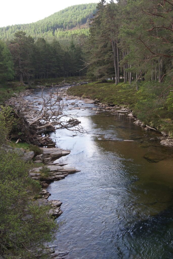
At Linn of Dee the open ground walked since Glen Feshie’s woods gave way to Scots pine plantation and I dropped down towards the Dee to try and find a sheltered camping spot at the Linn of Dee, a gorge where the Dee pitches through a narrow defile of rock. Finally I came along a small dirt path to a flat area tucked under a steep wooded bank. The Dee flowed into a wide deep brown pool between two sets of rapids, and behind me there was a steep bank of Scots pines with swathes of wortleberry (blueberry) bushes at their feet.
Turning in
Despite being ready to drop I got the tent up before I lost all motivation and ended up sleeping in the open. Bivvying is where people do sleep in the open in their survival bags, but I’m not tough enough to try this in Scotland in May. My tea for tonight was pasta boiled up with dried tomatoes, jerky and chilli flakes. I’d gone a bit heavy on the chilli but it definitely warmed me through; I always use a stove to keep the flame off the ground, never making a fire at any time of the year. On peat a burn will spread underground and is very difficult to stop. At date of writing (13 June) Cannich in Highlands burned 1,500 hectares over a week at the worst time of year: ground nesting birds are raising their chicks and adders, grass snakes and lizards are just coming out of hibernation.
The sky never gets properly dark and you sleep in a peachy twilight
At Linn of Dee I lay down in the tent in the peace. A little finger long fish swam in the pool and I lay on my back and watched light sparkling on the ruffled water at the top of the pool, the wind making cat’s paws swishing over the smooth surface . The light gold, ripples radiating out gently from the soft impact of debris falling from the trees. Mayflies dipped down to the surface, barely touching it, and feathered back up again.
At 6pm I went to sleep. I tend to wake in the early hours when the temperature drops and the time you go to sleep doesn’t really matter at this time of the year. The sky never gets properly dark and you sleep in a peachy twilight. I woke later and popped my head out of the tent, everything still clearly visible, the moon shining in the branches of the trees to my right. Which meant no cloud cover. Which meant an incoming significant drop in temperature.
A cold welcome
I woke about 5am tense with cold: 2oC according to the Met Office app. I got up and warmed up wresting everything back in my rucksack. That combination of the elemental and the seriously practical: getting the tent down in the right order, the technicals of compression sacks, balancing and securing the pack, sorting to make sure that everything for the bus journey from Braemar was accessible. Then the sublime: sitting on a flat rock over the pool, eating a cereal bar, sketching a pine cone, taking photographs and painting. Then up for the hopefully gentle 6 miles into Braemar.
Once strapped into my pack I climbed up through the hanger to a quiet road winding through hushed pines in the cold morning air, sun gently warm on my face, perfect walking. At a sign to the right for Mar Lodge I turned down the hill and through a gate onto a path alongside the Dee marked by black arrows on posts. It looped round the front of the (frankly bonkers) Mar Lodge, onto the Victoria Bridge out onto the Braemar road. It was a quiet trudge gently uphill at first through woods, but increasingly busy with cars carrying mountain bikes.
As the road emerged from the trees there were two laybys just beyond the farm at Corriemulzie, the Dee gently meandering below, the laybys full of campervans and motorhomes that day.
At the end of the first right hand layby my path continued through a metal latched pedestrian gate (there are 2 gates, the first track the wrong way) and then was climbing up through a maze of forest tracks. I kept getting turned around and eventually pulled up my OS mapping app and used that (I also carry a paper map, but that was buried somewhere in the pack).
Bird in view
Suddenly the trees cleared and I came out onto Morrone Birkwood, heath dotted with birch high above the Dee. The path ahead was wide and white, undulating through the heather in the sun towards Tomintoul viewpoint and led me to a bench. Thankful for the rest, I looked out clearly at the big hills above the Lairig Ghru. Snow was still in the mighty corries. A small raptor I couldn’t identify dipped up and down. From behind the trees to my right a buzzard glided into view and hooked into a thermal to my left, keening that chilling call.
The path went straight on through trees to a signpost pointing three ways down to Braemar. I decided on the steep path down to the Clunie Water onto the Old Military Road for a quiet steady walk beside the Clunie Water into the village centre for brunch.
Once suitably tanked up with coffee and a very good gluten free breakfast I walked around the corner to the bus stop. Braemar was busy with tourists but no one seemed to notice the spectacle and noise above them. In the trees jackdaws were chacking away, the sound pierced through by the screaming of the swifts, black hurtling twisting scythes in the clear sunlight.
The bus came and followed the scenic A92 alongside the Dee to Aberdeen, where I changed onto the coach that wound along the east coast south to home. Train and plane also go from Aberdeen, you can even take the ferry from the harbour north to Orkney and Shetland for further adventures!
Jo Bennie
Born in Cambridge, Jo has lived in or near Dundee in the north east of Scotland since 1993 when she went to university there. The last three years have seen Jo “take to the hills” (literally) in Scotland, and she credits them as her teachers.
“I began by climbing the Sidlaw Hills above Dundee close to my house in Carnoustie. Next came overnight solo camping in the Angus Glens. I will continue to return to their quiet loveliness and find new sanctuaries among the ‘big hills’ of the Cairngorms. The wild camping and the movement forward in solitude brings me respite from a life complicated by autism, bipolar and long covid. For the only thing of concern to be the next step forwards. Through heather and bog and forest in the glories of the Scottish weather, consistent only in its mercurial changeability.”
Inspired to prepare for your own Scottish adventure? Why not sign up to walk and review Slow Ways. You can also find and follow us on Instagram, Twitter and Facebook.